The Ribble Valley remains one of England’s best-kept secrets, a sprawling patchwork of verdant pastures, dramatic limestone scars, and ancient woodland nestled in the heart of Lancashire.
While many hikers flock to the nearby Lake District or the Yorkshire Dales, the Ribble Valley offers a more intimate, tranquil experience. It is a landscape defined by the meandering River Ribble and the looming, iconic presence of Pendle Hill, providing a variety of terrain that caters to every level of ambition.
From the manicured trails surrounding Clitheroe Castle to the rugged, wind-swept tracks of the Forest of Bowland—an Area of Outstanding Natural Beauty—the walking opportunities here are as diverse as the history that shaped them.
You can trace the footsteps of the Jesuit poets at Stonyhurst, follow the paths of the legendary Pendle Witches, or simply enjoy a level riverside ramble ending at a world-class country inn.
This guide is designed to help you navigate this complex landscape, offering practical, first-hand insight into the routes that best showcase the valley’s unique character, whether you are seeking a challenging day on the fells or a gentle afternoon stroll through a quintessential English village.
Easy Walks in Ribble Valley (Under 3 Miles)
These routes are ideal for families with young children, those with limited mobility, or anyone looking for a brief breath of fresh air without the need for specialist hiking gear.
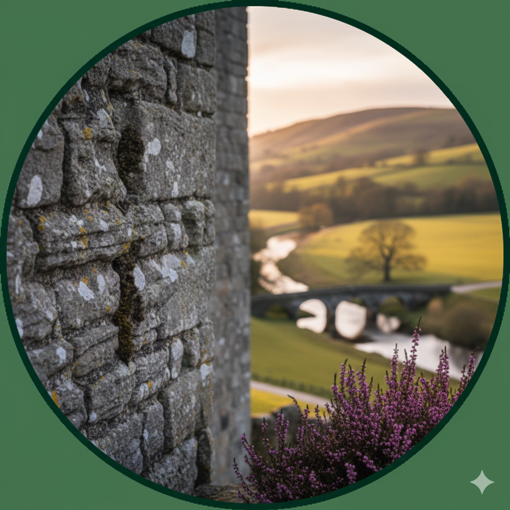
Clitheroe Castle Circular
- Location: Clitheroe Town Centre (BB7 1BA)
- Distance: 1.5 miles
- Duration: 45 minutes – 1 hour
- Difficulty: Easy
- Terrain: Tarmac paths, some steady inclines up to the keep.
This walk is the perfect introduction to the Ribble Valley’s “capital.” The castle sits atop a limestone outcrop, offering 360-degree views of the town and Pendle Hill. The grounds are beautifully maintained with accessible paths. After circling the ramparts, wander through the rose gardens and the labyrinth.
- Parking: Numerous short and long-stay car parks in Clitheroe town centre.
- Suitability: Excellent for dogs (on leads) and pushchairs.
- Best Time: Year-round; the paths remain dry even in mid-winter.
Brungerley Park and Sculptures
- Location: Waddington Road, Clitheroe
- Distance: 2 miles
- Duration: 1 hour
- Difficulty: Easy
- Terrain: Mostly flat riverside paths; can be muddy after rain.
Starting from the edge of Clitheroe, this walk follows the River Ribble through Brungerley Park and into Waddow Hall’s outskirts. Look out for the various sculptures hidden among the trees, part of the Ribble Valley Sculpture Trail. It is a peaceful, shaded route that feels far removed from the town.
- Parking: Small car park at Brungerley Bridge or street parking nearby.
- Highlights: Kingfishers and otters are occasionally spotted here.
Village and Riverside Walks
The Ribble Valley is famous for its award-winning villages. These walks combine scenic river views with the charm of local architecture and historical landmarks.
The Whalley Riverside Loop
- Location: Whalley Village (BB7 9SS)
- Distance: 3.5 miles
- Duration: 1.5 – 2 hours
- Difficulty: Easy to Moderate
- Terrain: Riverbank paths, woodland tracks, and some village pavements.
Starting at the ruins of Whalley Abbey, this route takes you under the magnificent 48-arch Whalley Viaduct, the longest brick-built structure in Lancashire. You follow the River Calder before looping back through the village. The terrain is largely flat, but the woodland sections near the river can be slippery.
- Parking: Whalley Abbey car park or the large village car park near the primary school.
- Highlights: The Cistercian Abbey ruins and the towering Victorian viaduct.
- Suitability: Great for families; Whalley has excellent cafes and shops for post-walk refreshments.
Dunsop Bridge and the River Dunsop
- Location: Dunsop Bridge (BB7 3BB)
- Distance: 4 miles (out and back)
- Duration: 2 hours
- Difficulty: Easy
- Terrain: Flat, well-surfaced estate roads and gravel tracks.
Dunsop Bridge is famously cited by the Ordnance Survey as the nearest village to the exact geographic centre of Great Britain. This walk follows the river upstream into the Trough of Bowland. Because the path is largely a private access road for the local estate, it is exceptionally easy underfoot and perfect for a steady, scenic stroll surrounded by high fells.
- Parking: P&D car park in the centre of Dunsop Bridge.
- Highlights: The famous “Centre of the Kingdom” phone box and the pristine waters of the River Dunsop.
Moderate Countryside Walks
For those who want to venture further into the fields and experience the “rolling” nature of the Lancashire landscape, these mid-range walks offer spectacular views with a bit more physical effort.
The Tolkien Trail (Hurst Green)
- Location: Hurst Green (BB7 9QP)
- Distance: 5.5 miles
- Duration: 3 hours
- Difficulty: Moderate
- Terrain: Field paths, woodland trails, and some road walking. Can be very muddy in winter.
This is arguably the most famous walking route in the Ribble Valley. J.R.R. Tolkien spent considerable time at Stonyhurst College during the Second World War, and many believe the local landscape inspired the Shire in The Lord of the Rings. The route takes you past the majestic college, through the Cromwell’s Bridge area, and along the confluence of the Ribble, Hodder, and Calder.
- Parking: Street parking in Hurst Green village; please park considerately.
- Highlights: Stonyhurst College, the “Shire-like” scenery, and the hauntingly beautiful Hacking Woods.
- Best Time: Spring for the bluebells in the woods or Autumn for the changing leaves.
Downham and Twiston Circular
- Location: Downham Village (BB7 4DN)
- Distance: 5 miles
- Duration: 2.5 hours
- Difficulty: Moderate
- Terrain: Grassy footpaths, stiles, and quiet country lanes.
Downham is frequently cited as the most beautiful village in Lancashire, famously free of overhead wires and road signs. This walk skirts the base of Pendle Hill, offering stunning views of the peak without the steep climb. It leads through the hamlet of Twiston, providing a true sense of rural isolation.
- Parking: Free village car park at the bottom of the hill in Downham.
- Highlights: The unspoiled village of Downham and views of the “Big End” of Pendle Hill.
- Suitability: Not suitable for pushchairs due to numerous traditional stone stiles.
Challenging Scenic Hikes
These routes require a good level of fitness, sturdy walking boots, and basic navigation skills. The weather on the higher ground can change rapidly.
The Pendle Hill Summit (from Barley)
- Location: Barley Village (BB12 9JX)
- Distance: 5 miles
- Duration: 2.5 – 3.5 hours
- Difficulty: Challenging
- Terrain: Very steep stone steps (“The Steps”), peat moorland, and gravel tracks.
No guide to Ribble Valley walks is complete without Pendle Hill. While there are many ways up, the ascent from Barley via the direct steps is the most popular. The climb is punishingly steep but short. Once on the plateau, the view extends to the Yorkshire Three Peaks and, on clear days, the Blackpool Tower and the Irish Sea. The descent via Ogden Reservoirs provides a gentler return to the village.
- Parking: Large P&D car park in Barley. It fills up very early on weekends.
- Suitability: Not suitable for young children unless they are experienced walkers. Dogs must be on leads due to ground-nesting birds and sheep.
- Warning: The summit is often 5°C colder than the village and can be shrouded in mist.
Longridge Fell (Spire Hill)
- Location: Jeffrey Hill (PR3 2TT)
- Distance: 4.5 miles
- Duration: 2.5 hours
- Difficulty: Moderate to Challenging
- Terrain: Forest tracks and peaty moorland paths.
Longridge Fell is the southernmost fell in England. Starting from the high vantage point of Jeffrey Hill, the walk takes you through managed forestry plantations to the trig point at Spire Hill. The “challenge” here is often the terrain; it can be incredibly boggy, requiring careful footwork. However, the views across the Loud Valley toward Bowland are unparalleled.
- Parking: Small car park at Jeffrey Hill.
- Highlights: Dramatic views of the Ribble Valley and a sense of true wilderness in the forestry sections.
Gisburn Forest: The Birch Hill Loop
- Location: Gisburn Forest Hub (BB7 4TS)
- Distance: 6 miles
- Duration: 3 hours
- Difficulty: Moderate
- Terrain: Forestry tracks, some uneven roots, and steady climbs.
While famous for mountain biking, Gisburn Forest offers superb, waymarked walking trails. The Birch Hill loop provides elevated views over Stocks Reservoir. It is a deep-forest experience that feels different from the open farmland found elsewhere in the valley.
- Parking: Gisburn Forest Hub (P&D).
- Highlights: Wildlife—look out for Sika deer and various birds of prey.
Planning Your Walk in Ribble Valley
A successful day on the Lancashire footpaths requires a bit of preparation. The Ribble Valley is a working landscape, and conditions can vary wildly depending on the season.
Parking Considerations
Popular spots like Barley and Downham can become congested on sunny weekends and bank holidays. To ensure a stress-free start, aim to arrive before 10:00 am.
In villages like Hurst Green, always use designated parking areas where available to avoid blocking access for local farmers and residents.
Weather and Footwear
The clay-heavy soil of the Ribble Valley means that “moderate” walks can become “challenging” after a week of rain.
- Winter/Spring: Waterproof hiking boots are essential. Many field crossings become exceptionally muddy.
- Summer: Even in dry weather, the summit of Pendle Hill remains exposed. Always carry a windproof layer.
- Navigation: While many routes are well-signed, carrying an OS Map (Explorer OL41 covers the Forest of Bowland and Ribble Valley) is highly recommended for any walks over 4 miles.
Countryside Code
Much of the walking in the Ribble Valley crosses private farmland.
- Livestock: You will almost certainly encounter sheep and cattle. Keep dogs on short leads around livestock, especially during lambing season (March–May).
- Gates: Always leave gates as you find them.
- Waste: There are no bins on the fells or in the deep countryside; please carry all litter back to the village centres.
Seasonal Variations
- Spring: Perfect for the Tolkien Trail and woodland walks to see bluebells.
- Summer: Best for the high fells and long evening strolls along the Ribble.
- Autumn: The Ribble Valley’s ancient woodlands, such as those near Dinckley and Hacking Boat, put on a spectacular display of colour.
- Winter: Ideal for the paved routes around Dunsop Bridge or the Castle grounds when the fields are saturated.
More Walks in the Ribble Valley
-

Ribble Valley for Couples: Romantic Things to Do
-

The Timeless Charm of Waddington: A Jewel in the Ribble Valley’s Crown
-

A Guide to Gisburn Forest Trails
-

Why Ribble Valley Is One of England’s Best-Kept Secrets
-
 6")
The Best Walks in the Ribble Valley (From Easy Strolls to Scenic Hikes)
-

Free Things to Do in the Ribble Valley This Weekend
-

The Story Behind Dunsop Bridge – The Centre of Britain
-

The Best 5 Walks in the Ribble Valley: A Hiker’s Guide to Lancashire’s Hidden Heart
-

Scaling Jeffery Hill: Longridge’s Gateway to the Bowland Wilderness
-

Scarloom Waterfall: Discovering the Ribble Valley’s Best-Kept Secret
-

Is Whalley Worth Visiting? A Deep Dive into the Ribble Valley’s Most Vibrant Village
-

What to Do in the Ribble Valley: The Ultimate Insider’s Guide to Lancashire’s Heart
-

The Ultimate Pendle Hill Survival Guide: 2026 Edition
-

Following in the Footsteps of J.R.R. Tolkien: A Guide to the Tolkien Trail
-

The Ultimate Dog-Friendly Day in Clitheroe
-

Why Winter is the Best Time for a Ribble Valley Mini-Break
The Ribble Valley offers a rare combination of accessible beauty and rugged wilderness.
Whether you are traversing the haunting heights of Pendle Hill or enjoying a quiet moment by the River Hodder, the landscape invites a slower pace of life.
It is a region where history—from Roman roads to industrial heritage—is etched into the very trails you walk upon.
One of the greatest joys of walking in this part of Lancashire is the seasonal transformation; a route that feels bright and airy in July becomes atmospheric and dramatic in the mists of November.
There is always a new path to discover, a different valley to explore, and a warm village pub waiting at the end of the journey.
Take your time, respect the landscape, and immerse yourself in the natural splendour of the Ribble Valley.